
How Overflights Are Defined for This Analysis
For this analysis, an aircraft overflight is defined as a flight track that passes within a specific lateral distance of a subject location. This distance, as measured horizontally along the ground, varies based on the aircraft’s height.
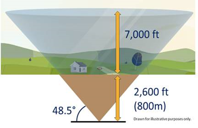
This overflight space or zone can be visualised as a truncated cone (cone with its point cut off), turned upside down. At ground level, the base of this cone has a radius of 700 metres. As aircraft altitude increases, the radius expands:
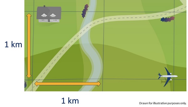
- At 1,000 feet, the radius is 1 kilometre
- At 7,000 feet, the radius extends to 2.6 kilometres
This means that an aircraft flying at 1,000 feet, passing within 1 kilometre of a location, is counted as an overflight. If the aircraft is beyond 1 kilometre, it is not classified as an overflight.
For aircraft above 7,000 feet, even if flying directly overhead, the event is not included in this noise-based overflight definition. While the aircraft may be visible and sometimes audible, noise levels at this altitude are too low to significantly contribute to the local noise environment.
How Overflight Data is Collected
Our Noise and Flight Track Monitoring System (ANOMS) calculates overflight data for every point in a 1 km x 1 km grid, covering an area of approximately 95 km from the airport.
For locations referenced by an Eircode, ANOMS reports overflight data based on the nearest grid point.
The following video explains how the system calculates location-specific data, which is used throughout this website.
Why a Cone-Shaped Overflight Zone is Used
The cone-shaped overflight zone ensures that overflight numbers are not underestimated and that all locations in our monitoring grid are accurately accounted for. The cone’s ground-level radius increases with altitude, reflecting how noise disperses as aircraft gain height.
This definition of Overflight was developed by the UK Civil Aviation Authority (CAA) based on how individuals subjectively perceive whether an aircraft has overflown a location. The 48.5-degree angle of the cone was selected to incorporate noise considerations. If one aircraft flies directly overhead, and a second aircraft flies 48.5 degrees to the side, the second aircraft will be perceived as 3 decibels quieter than the first (all other things being equal).
To avoid underestimation, the cone is cut off at the base, effectively lowering it 800 metres (2,600 feet) into the ground. The cone extends up to 7,000 feet above ground level, and at its highest point, it has a diameter exceeding 5 kilometres.
This structured approach is aimed at ensuring that overflight data reflects both physical proximity and perceived noise impact, providing a realistic and consistent method for categorising overflights.
Where Does the Data Come From?
The data in our Aircraft Noise and Operations Monitoring System (ANOMS) is based on real-time flight data from air traffic control radar.
